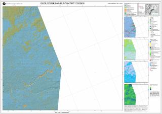
Geologisk havbunnskart, Barentshavet. Kart 73303600 M 1:100 000
| dc.contributor.author | Jakobsen, F. | |
| dc.contributor.author | Dolan, M. | |
| dc.contributor.author | Bellec, V. | |
| dc.contributor.author | Elvenes, S. | |
| dc.contributor.author | Lepland, A. | |
| dc.contributor.author | Bjarnadóttir, L.R. | |
| dc.contributor.author | Bøe, R. | |
| dc.contributor.author | Rise, L. | |
| dc.contributor.author | Thorsnes, T. | |
| dc.contributor.author | Selboskar, O.H. | |
| dc.contributor.author | Olsen, H. | |
| dc.contributor.author | Plassen L. | |
| dc.contributor.author | Nixon, F.C. | |
| dc.date.accessioned | 2020-07-09T11:41:40Z | |
| dc.date.available | 2020-07-09T11:41:40Z | |
| dc.date.issued | 2018 | |
| dc.identifier.uri | https://hdl.handle.net/11250/2661652 | |
| dc.description.abstract | Utgitt 2017, oppdatert 2018.På kartet: Kornstørrelse M 1:100 000, Landskap og landformer M 1:500 000, Jordart M 1:500 000, Sedimentasjonsmiljø M 1:500 000, Bunnreflektivitet fra multistråleekkolodd M 1:500 000 | |
| dc.language.iso | nor | |
| dc.rights | Navngivelse 4.0 Internasjonal | |
| dc.rights.uri | http://creativecommons.org/licenses/by/4.0/deed.no | |
| dc.subject | KORNSTØRRELSE | |
| dc.subject | AVSETNING | |
| dc.subject | SEDIMENTASJON | |
| dc.subject | MARINGEOLOGI | |
| dc.subject | HAVBUNN | |
| dc.subject | HAVBUNNSTOPOGRAFI | |
| dc.title | Geologisk havbunnskart, Barentshavet. Kart 73303600 M 1:100 000 | |
| dc.type | Map | |
| dc.description.localcode | 65412 | |
| dc.source.pagenumber | 1 kart |
Files in this item
This item appears in the following Collection(s)
-
Kart [1000]
NGUs trykte kart

Except where otherwise noted, this item's license is described as Navngivelse 4.0 Internasjonal