En kort redegjørelse for resultaterne fra kortlægningen af Altevatnområdet i Indre Troms.
| dc.contributor.author | Holst Mortensen, Arvid | |
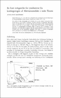
| dc.coverage.spatial | 15322 Altevatn | |
| dc.coverage.spatial | 15311 Gæv'dnjajav'ri | |
| dc.coverage.spatial | 15323 Salvasskardet | |
| dc.date.accessioned | 2020-08-26T13:10:04Z | |
| dc.date.available | 2020-08-26T13:10:04Z | |
| dc.date.issued | 1972 | |
| dc.identifier.uri | https://hdl.handle.net/11250/2674948 | |
| dc.description.abstract | An outline of the stratigraphy and tectonics of an areasituated across the Caledonian thrust front south of Altevatn, northernNorway, is presented. The lithologies are described and it is shownthat the stratigraphy of the metasupracrustal rocks in this area isvery similar to that found immediately to the north of Altevatn. Astratigraphical correlation with an adjacent area, in Sweden, is alsoattempted, and from this it appears that the metamorphosedsupracrustals in this marginal part of the Caledonian mountain chainhave a common stratigraphy over a distance of ca. 80 km fromMåskanvarri to Tornetræsk. | |
| dc.language.iso | nor | |
| dc.relation.ispartofseries | NGU (277) | |
| dc.rights | Navngivelse 4.0 Internasjonal | |
| dc.rights.uri | http://creativecommons.org/licenses/by/4.0/deed.no | |
| dc.subject | KARTLEGGING | |
| dc.subject | STRATIGRAFI | |
| dc.subject | PETROGRAFI | |
| dc.subject | TEKTONIKK | |
| dc.title | En kort redegjørelse for resultaterne fra kortlægningen af Altevatnområdet i Indre Troms. | |
| dc.type | Journal article | |
| dc.description.localcode | 35159 | |
| dc.source.pagenumber | 7-16 |
Tilhørende fil(er)
Denne innførselen finnes i følgende samling(er)
-
Artikler [1064]
Artikler fra seriene NGU, NGU Bulletin og NGU Skrifter

Med mindre annet er angitt, så er denne innførselen lisensiert som Navngivelse 4.0 Internasjonal