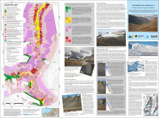
Landforms and sediments in Todalen and upper Gangdalen and Bødalen, Svalbard. Scale 1:25 000
| dc.contributor.author | Eckerstorfer, Markus | |
| dc.contributor.author | Rubensdotter, Lena | |
| dc.contributor.author | Stalsberg, Knut | |
| dc.contributor.author | Christiansen, Hanne | |
| dc.contributor.author | Trøyen, Priita | |
| dc.date.accessioned | 2020-07-09T11:50:08Z | |
| dc.date.available | 2020-07-09T11:50:08Z | |
| dc.date.issued | 2015 | |
| dc.identifier.isbn | 978-82-7385-152-9 | |
| dc.identifier.uri | https://hdl.handle.net/11250/2661800 | |
| dc.description.abstract | The landscape story told on this map is the result of geology, geomorphology and climate driven processes in high arctic Svalbard. The map informs about the landscape we see today and also gives information about hazards and challenges we face when traveling in it. | |
| dc.language.iso | eng | |
| dc.rights | Navngivelse 4.0 Internasjonal | |
| dc.rights.uri | http://creativecommons.org/licenses/by/4.0/deed.no | |
| dc.subject | KVARTÆRGEOLOGI | |
| dc.subject | GEOMORFOLOGI | |
| dc.subject | KARTLEGGING | |
| dc.subject | LØSMASSE | |
| dc.title | Landforms and sediments in Todalen and upper Gangdalen and Bødalen, Svalbard. Scale 1:25 000 | |
| dc.type | Map | |
| dc.description.localcode | 65513 | |
| dc.source.pagenumber | 1 kart |
Files in this item
This item appears in the following Collection(s)
-
Kart [1000]
NGUs trykte kart

Except where otherwise noted, this item's license is described as Navngivelse 4.0 Internasjonal