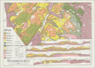
NGU 292 Geology of the quadrangles 1314 I Røldal and 1414 IV Haukelisæter north of highway E76
| dc.contributor.author | Naterstad, Johan | |
| dc.contributor.author | Jorde, Knut | |
| dc.contributor.author | Andresen, Arild | |
| dc.coverage.spatial | VINJE | |
| dc.coverage.spatial | ULLENSVANG | |
| dc.coverage.spatial | TELEMARK | |
| dc.coverage.spatial | VESTLAND | |
| dc.coverage.spatial | 14144 Haukelisæter | |
| dc.coverage.spatial | 13141 Røldal | |
| dc.date.accessioned | 2020-07-09T14:25:06Z | |
| dc.date.available | 2020-07-09T14:25:06Z | |
| dc.date.issued | 1973 | |
| dc.identifier.uri | https://hdl.handle.net/11250/2663501 | |
| dc.description.abstract | Kartet er bilag i NGU nr. 292. Tectonic succession of the Caledonian nappe front in the Haukelisæter- Røldal area, Southwest Norway : Mapping by Johan Naterstad, Arild Andresen and Knut Jorde 1968-1971 | |
| dc.language.iso | nor | |
| dc.rights | Navngivelse 4.0 Internasjonal | |
| dc.rights.uri | http://creativecommons.org/licenses/by/4.0/deed.no | |
| dc.subject | BERGGRUNNSGEOLOGI | |
| dc.title | NGU 292 Geology of the quadrangles 1314 I Røldal and 1414 IV Haukelisæter north of highway E76 | |
| dc.type | Map | |
| dc.description.localcode | 66635 | |
| dc.source.pagenumber | 1 kart |
Tilhørende fil(er)
Denne innførselen finnes i følgende samling(er)
-
Kart [1000]
NGUs trykte kart

Med mindre annet er angitt, så er denne innførselen lisensiert som Navngivelse 4.0 Internasjonal