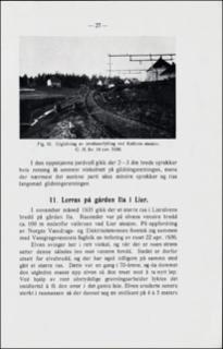
Lerras på gården Ila i Lier.
| dc.contributor.author | Holmsen, Gunnar | |
| dc.coverage.spatial | 18144 Lier | |
| dc.date.accessioned | 2020-08-26T12:39:32Z | |
| dc.date.available | 2020-08-26T12:39:32Z | |
| dc.date.issued | 1946 | |
| dc.identifier.uri | https://hdl.handle.net/11250/2674560 | |
| dc.description.abstract | In November 1935 the ground on the left hand beach of the Lier stream fell down. The place is situated a hundred meters downstreams a bridge near Lier station on the railway to Drammen. 70 years previously a slide occurred at this very place. Since then the stream had eroded a steep wall, 4-5 m high, in the old slided masses, while a several m deep pool had been formed under the wall. Owing to this unstable formation the new falling occurred. The surface of the old slide sloped 19 m between the edge of the slide and the stream's water level. The distance is 40 m. This makes nearly an inclination of 1:2. It is of some interest to note that the new slide rests with a slighter slope, 1:3,5. | |
| dc.language.iso | nor | |
| dc.relation.ispartofseries | NGU (166) | |
| dc.rights | Navngivelse 4.0 Internasjonal | |
| dc.rights.uri | http://creativecommons.org/licenses/by/4.0/deed.no | |
| dc.subject | AVSETNING | |
| dc.subject | LEIR | |
| dc.subject | SKREDAVSETNING | |
| dc.subject | SKREDFORM | |
| dc.subject | GRUS | |
| dc.subject | SAND | |
| dc.title | Lerras på gården Ila i Lier. | |
| dc.type | Journal article | |
| dc.description.localcode | 34915 | |
| dc.source.pagenumber | 27-29 |
Tilhørende fil(er)
Denne innførselen finnes i følgende samling(er)
-
Artikler [1064]
Artikler fra seriene NGU, NGU Bulletin og NGU Skrifter

Med mindre annet er angitt, så er denne innførselen lisensiert som Navngivelse 4.0 Internasjonal