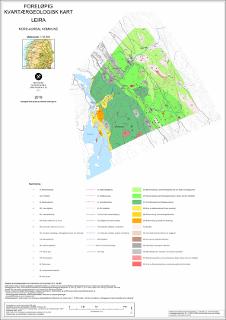
Foreløpig kvartærgeologisk kart Leira, Nord-Aurdal kommune. M 1:10 000
| dc.contributor.author | Rubensdotter, L. | |
| dc.contributor.author | Sandøy, G. | |
| dc.coverage.spatial | 17164 Aurdal | |
| dc.date.accessioned | 2020-07-01T13:55:06Z | |
| dc.date.available | 2020-07-01T13:55:06Z | |
| dc.date.issued | 2019 | |
| dc.identifier.uri | https://hdl.handle.net/11250/2660379 | |
| dc.description.abstract | Inkludert produktark (4 s.): Detaljerte kvartærgeologiske kart i bratt terreng - Rye-Follonglo, Strond, Leira og Aurdal-Nordåker (foreløpige kart), Nord-Aurdal kommune | |
| dc.language.iso | nor | |
| dc.rights | Navngivelse 4.0 Internasjonal | |
| dc.rights.uri | http://creativecommons.org/licenses/by/4.0/deed.no | |
| dc.subject | KVARTÆRGEOLOGI | |
| dc.subject | SKRED | |
| dc.subject | GEOLOGISK RISIKO | |
| dc.title | Foreløpig kvartærgeologisk kart Leira, Nord-Aurdal kommune. M 1:10 000 | |
| dc.type | Map | |
| dc.description.localcode | 66511 | |
| dc.source.pagenumber | 1 kart |
Files in this item
This item appears in the following Collection(s)
-
Kart [1000]
NGUs trykte kart

Except where otherwise noted, this item's license is described as Navngivelse 4.0 Internasjonal