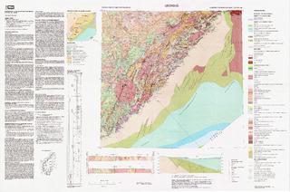
Arendal. Berggrunnskart Arendal M 1:250 000; trykt i farger
| dc.contributor.author | Padget, Peter | |
| dc.contributor.author | Brekke, Harald | |
| dc.coverage.spatial | LILLESAND | |
| dc.coverage.spatial | IVELAND | |
| dc.coverage.spatial | GRIMSTAD | |
| dc.coverage.spatial | GJERSTAD | |
| dc.coverage.spatial | FROLAND | |
| dc.coverage.spatial | EVJE OG HORNNES | |
| dc.coverage.spatial | BYGLAND | |
| dc.coverage.spatial | BIRKENES | |
| dc.coverage.spatial | ARENDAL | |
| dc.coverage.spatial | TELEMARK | |
| dc.coverage.spatial | AGDER | |
| dc.coverage.spatial | RISØR | |
| dc.date.accessioned | 2020-07-09T13:57:56Z | |
| dc.date.available | 2020-07-09T13:57:56Z | |
| dc.date.issued | 1996 | |
| dc.identifier.uri | https://hdl.handle.net/11250/2662177 | |
| dc.description.abstract | Beskrivelsen finnes på kartet. | |
| dc.language.iso | nor | |
| dc.rights | Navngivelse 4.0 Internasjonal | |
| dc.rights.uri | http://creativecommons.org/licenses/by/4.0/deed.no | |
| dc.subject | BERGGRUNNSGEOLOGI | |
| dc.title | Arendal. Berggrunnskart Arendal M 1:250 000; trykt i farger | |
| dc.type | Map | |
| dc.description.localcode | 42160 | |
| dc.source.pagenumber | 1 kart |
Files in this item
This item appears in the following Collection(s)
-
Kart [1000]
NGUs trykte kart

Except where otherwise noted, this item's license is described as Navngivelse 4.0 Internasjonal