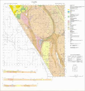
Cier'te. Berggrunnskart; Cier'te; 17332; 1:50 000; trykt i farger; NGU Skrifter nr. 20, publikasjon nr. 331 (1977)
| dc.contributor.author | Fareth, E. | |
| dc.contributor.author | Lindahl, I. | |
| dc.coverage.spatial | NORDREISA | |
| dc.coverage.spatial | TROMS | |
| dc.coverage.spatial | FINNMARK | |
| dc.coverage.spatial | KAUTOKEINO | |
| dc.coverage.spatial | 17332 Cier'te | |
| dc.date.accessioned | 2020-07-09T14:23:40Z | |
| dc.date.available | 2020-07-09T14:23:40Z | |
| dc.date.issued | 1977 | |
| dc.identifier.uri | https://hdl.handle.net/11250/2663430 | |
| dc.language.iso | nor | |
| dc.rights | Navngivelse 4.0 Internasjonal | |
| dc.rights.uri | http://creativecommons.org/licenses/by/4.0/deed.no | |
| dc.subject | BERGGRUNNSGEOLOGI | |
| dc.title | Cier'te. Berggrunnskart; Cier'te; 17332; 1:50 000; trykt i farger; NGU Skrifter nr. 20, publikasjon nr. 331 (1977) | |
| dc.type | Map | |
| dc.description.localcode | 37238 |
Files in this item
This item appears in the following Collection(s)
-
Kart [1000]
NGUs trykte kart

Except where otherwise noted, this item's license is described as Navngivelse 4.0 Internasjonal