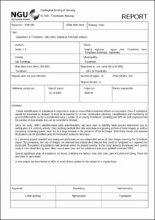
Subsidence in Trondheim, 1992-2003: Results of PSInSAR analysis
| dc.contributor.author | Dehls, John F. | |
| dc.coverage.spatial | 16214 Trondheim | |
| dc.date.accessioned | 2020-07-15T07:50:27Z | |
| dc.date.available | 2020-07-15T07:50:27Z | |
| dc.date.issued | 2005 | |
| dc.identifier.issn | 0800-3416 | |
| dc.identifier.uri | https://hdl.handle.net/11250/2664948 | |
| dc.description.abstract | Forkortet.\rTimely identification of subsidence is important in order to ensure that remediation efforts are successful. Even if subsidence cannot be prevented or stopped, it must be accounted for in new construction planning. Identification and monitoring of ground deformation can be accomplished using a number of surveying techniques. Levelling and GPS are both expensive and the number of benchmarks that can be controlled is limited. | |
| dc.language.iso | eng | |
| dc.relation.ispartofseries | NGU-Rapport (2005.082) | |
| dc.rights | Navngivelse 4.0 Internasjonal | |
| dc.rights.uri | http://creativecommons.org/licenses/by/4.0/deed.no | |
| dc.subject | FJERNANALYSE | |
| dc.title | Subsidence in Trondheim, 1992-2003: Results of PSInSAR analysis | |
| dc.type | Report | |
| dc.description.localcode | 52590 | |
| dc.source.pagenumber | 12 s. | |
| dc.relation.project | (300508) SAR Applications to Geohazards (ICG) |
Tilhørende fil(er)
Denne innførselen finnes i følgende samling(er)
-
Rapporter [5057]
NGU-rapporter

Med mindre annet er angitt, så er denne innførselen lisensiert som Navngivelse 4.0 Internasjonal