Graptolitførende skifere i vestre Gausdal.
| dc.contributor.author | Bjørlykke, Knut O. | |
| dc.coverage.spatial | 18174 Fåvang | |
| dc.coverage.spatial | 18173 Follebu | |
| dc.date.accessioned | 2020-08-26T12:32:48Z | |
| dc.date.available | 2020-08-26T12:32:48Z | |
| dc.date.issued | 1891 | |
| dc.identifier.uri | https://hdl.handle.net/11250/2674458 | |
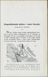
| dc.description.abstract | Forkortet:The Vestre Gausdal is situated in the central part of Southern Norway, 145 kmnorth of Oslo. It lies on the border-zone between the sparagmite-formation,which is Cambrian, and the overlying Silurian schists, which are widelyextended over the higher parts of Southern Norway. The sparagmite-formationconsists in the region under consideration of gray arcose and argillaceousschists. The small river Vigga will be found in the north-western part of thesketch-map p.1. A section along the river is given on p.8. Undermost we see aconglomerate (Kgl.) belonging to the sparagmite. Over it follows grey oftenarenaceous limestone (kalk); black in the map.Over this lie different varietiesof quartzite interstratified with argillaceous schists. Now follow argillaceousschists at least 150 m thich, in the upper part containing the graptolitesfigured p.3. They belong to the Arenig group, etage 4 a of Brøgger. Uppermostwe have alternating strata of grayish clay-schist and arenaceous schists (St.). | |
| dc.language.iso | nor | |
| dc.relation.ispartofseries | NGU (1) | |
| dc.rights | Navngivelse 4.0 Internasjonal | |
| dc.rights.uri | http://creativecommons.org/licenses/by/4.0/deed.no | |
| dc.subject | PETROGRAFI | |
| dc.subject | SEDIMENTÆR BERGART | |
| dc.subject | FOSSIL | |
| dc.subject | KART | |
| dc.subject | OMDANNET BERGART | |
| dc.subject | PALEONTOLOGI | |
| dc.title | Graptolitførende skifere i vestre Gausdal. | |
| dc.type | Journal article | |
| dc.description.localcode | 36235 | |
| dc.source.pagenumber | 1-10 |
Files in this item
This item appears in the following Collection(s)
-
Artikler [1064]
Artikler fra seriene NGU, NGU Bulletin og NGU Skrifter

Except where otherwise noted, this item's license is described as Navngivelse 4.0 Internasjonal