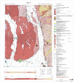
Drøbak. Berggrunnskart; Drøbak; 18142; 1:50 000; Foreløpig utgave plotteversjon
| dc.contributor.author | Hageskov, B. | |
| dc.contributor.author | Jorde, K. | |
| dc.coverage.spatial | MOSS | |
| dc.coverage.spatial | TØNSBERG | |
| dc.coverage.spatial | HOLMESTRAND | |
| dc.coverage.spatial | DRAMMEN | |
| dc.coverage.spatial | ASKER | |
| dc.coverage.spatial | ÅS | |
| dc.coverage.spatial | VIKEN | |
| dc.coverage.spatial | VESTFOLD | |
| dc.coverage.spatial | FROGN | |
| dc.coverage.spatial | VESTBY | |
| dc.coverage.spatial | NESODDEN | |
| dc.coverage.spatial | 18142 Drøbak | |
| dc.date.accessioned | 2020-07-09T13:53:10Z | |
| dc.date.available | 2020-07-09T13:53:10Z | |
| dc.date.issued | 2002 | |
| dc.identifier.uri | https://hdl.handle.net/11250/2662078 | |
| dc.language.iso | nor | |
| dc.rights | Navngivelse 4.0 Internasjonal | |
| dc.rights.uri | http://creativecommons.org/licenses/by/4.0/deed.no | |
| dc.subject | BERGGRUNNSGEOLOGI | |
| dc.title | Drøbak. Berggrunnskart; Drøbak; 18142; 1:50 000; Foreløpig utgave plotteversjon | |
| dc.type | Map | |
| dc.description.localcode | 56632 | |
| dc.source.pagenumber | 1 kart |
Files in this item
This item appears in the following Collection(s)
-
Kart [1000]
NGUs trykte kart

Except where otherwise noted, this item's license is described as Navngivelse 4.0 Internasjonal